Alice Springs Map: Street Map, Nearby Towns and Attractions
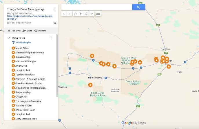
Alice Springs is a town in Australia’s Northern Territory, situated in the heart of the country’s Red Centre. Surrounded by arid landscapes, rugged mountain ranges and distinctive desert scenery, it provides an important base for exploring Central Australia. An Alice Springs map helps visitors understand the town’s location within Australia, identify surrounding landmarks and plan journeys through this remote region. Whether you are researching a future holiday or preparing for an outback road trip, understanding the geography makes travelling considerably easier.
The town lies along the Stuart Highway, a major route connecting different parts of the Northern Territory with southern Australia. Its central position makes it a useful starting point for visiting natural attractions, historical sites and nearby communities. However, distances between destinations can be substantial, and travel conditions may change. Before setting out, use a reliable regional map to check your intended route, identify available services and understand how far each attraction is from your accommodation.
Alice Springs Street Map and Town Layout
An Alice Springs street map helps visitors navigate the central business district, residential neighbourhoods and main transport routes. The town centre contains shops, cafés, accommodation and visitor services, making it a convenient starting point for exploring the area. Todd Mall is a useful landmark for locating central facilities and planning short walks. By identifying streets and nearby attractions before leaving your accommodation, you can organise sightseeing efficiently and spend less time searching for destinations.
The wider town layout includes important roads such as the Stuart Highway, Larapinta Drive and Ross Highway. These routes connect the urban area with surrounding attractions and regional destinations. A detailed map can help you distinguish local streets from roads leading into the outback, where facilities may be less frequent. Check directions before driving, particularly if you are unfamiliar with Australian road conditions. Keeping a digital map and a printed alternative available can make navigation more convenient.
Alice Springs Map With Nearby Towns and Places
A regional map reveals how Alice Springs connects with nearby settlements, natural landmarks and destinations throughout Central Australia. Hermannsburg, also known as Ntaria, is one place visitors may wish to research when exploring the region’s cultural history. Other destinations include the West MacDonnell Ranges and several communities accessible by regional roads. Checking their locations helps travellers decide which places can be visited on a day trip and which require additional time, accommodation or special travel arrangements.
When planning an excursion, consider road distance rather than simply measuring the space between locations on a map. Desert roads, changing conditions and limited services can affect journey times. Some routes may also have access restrictions or require a suitable vehicle. Before departing Alice Springs, check current road information and identify fuel stops, water supplies and available facilities. This preparation is particularly important when travelling beyond the town, where mobile reception and assistance may be limited.
Alice Springs Map to Uluru and Kings Canyon
Uluru is one of Australia’s best-known natural landmarks and a major destination for visitors exploring the Red Centre. A regional map shows its position south-west of Alice Springs and helps travellers understand the route towards Uluru-Kata Tjuta National Park. The journey requires advance planning because it involves a considerable amount of driving. Visitors should check current distances, estimated travel times, accommodation availability and park information before leaving, particularly if they intend to explore several destinations during the same trip.
Kings Canyon, within Watarrka National Park, offers dramatic sandstone scenery, walking opportunities and impressive natural formations. An Alice Springs map can help visitors compare possible routes and decide how to incorporate the canyon into a wider itinerary. Depending on the route and road conditions, travelling there may require several hours. Check official park guidance, walking track information and weather conditions before setting off. Allow enough time for driving, rest stops and sightseeing rather than trying to fit too many distant attractions into one day.
Tourist Attractions on the Alice Springs Map
Mapping local attractions makes it easier to plan a balanced visit without repeatedly travelling across town. Alice Springs offers a combination of cultural experiences, historical landmarks, wildlife attractions and scenic viewpoints. Visitors can use a town map to identify places near their accommodation and group nearby activities together. This approach is especially helpful for short stays, when choosing an efficient route can leave more time to explore each destination instead of spending unnecessary time travelling between locations.
Popular attractions include Alice Springs Desert Park, Anzac Hill, the Telegraph Station Historical Reserve and Olive Pink Botanic Garden. Each offers a different perspective on the area’s natural environment, history or cultural character. Before visiting, check official websites for opening times, entry arrangements and access information. Some attractions may have seasonal schedules or temporary restrictions. Using current visitor information alongside a map helps you choose suitable stops and avoid arriving at a location when it is closed.
Alice Springs Desert Park and the MacDonnell Ranges
Alice Springs Desert Park introduces visitors to the wildlife, plants and environments of Central Australia. Its dedicated visitor information and interactive map can help guests understand the layout, locate facilities and plan their route around the grounds. The park provides an opportunity to learn about desert ecosystems without travelling far into remote country. Check its official website before visiting to confirm opening hours, current experiences and any practical information needed to prepare for your day.
The MacDonnell Ranges provide a striking backdrop to Alice Springs, with rocky landscapes, walking opportunities and natural attractions such as Simpsons Gap. A regional map helps visitors identify access roads and understand how individual sites fit into a wider sightseeing route. Conditions can vary with the weather, and some walking tracks may close temporarily. Check park alerts before departure, carry sufficient water and allow time for the return journey. These precautions help make exploring the surrounding landscape more comfortable and manageable.
Alice Springs Map PDF and Printable Maps
A printable map is particularly useful when travelling through remote areas where mobile reception may be unreliable. Tourism Central Australia provides downloadable maps and visitor guides covering Alice Springs and the surrounding Red Centre. Depending on availability, resources may include town maps and guides for destinations such as Uluru, Kings Canyon and the MacDonnell Ranges. Saving the relevant documents before travelling gives you an accessible reference for planning routes, identifying attractions and reviewing regional geography.
To find available resources, visit the Tourism Central Australia Maps and Guides page. Choose the map that matches your itinerary, download the file and save it to your phone or tablet. You can also print the pages you expect to need. Check the publication date and remember that printed maps may not reflect temporary road closures, updated facilities or changing access conditions. Use current official travel information for decisions that depend on the latest conditions.
How to Use Google Maps in Alice Springs
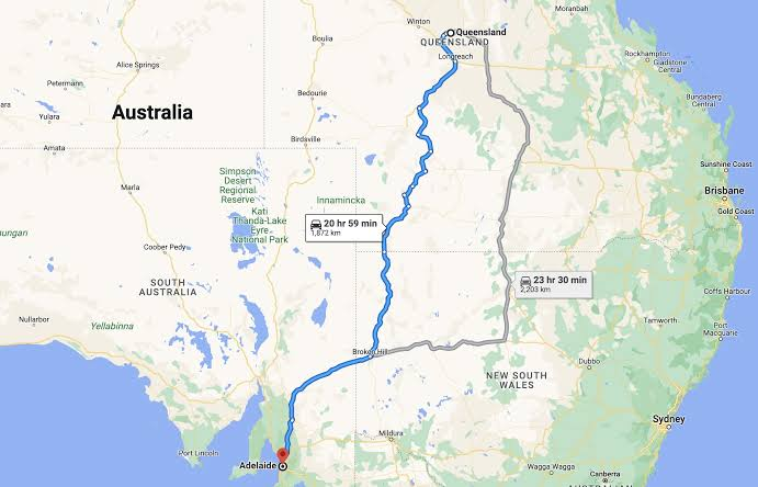
Google Maps is useful for locating accommodation, restaurants, petrol stations, shops and attractions around Alice Springs. Enter the name or address of your destination to review directions and estimated journey times. You can compare routes, identify nearby services and save useful locations before travelling. For visitors unfamiliar with the town, these tools provide a convenient way to organise daily activities and understand how local streets connect with the main roads leading out of the area.
Outside the town, mobile coverage may be limited, so download suitable offline maps before travelling where the feature is supported. Check that the required area is included and that your saved maps are accessible without an internet connection. Digital navigation should not be your only preparation for remote driving. Carry a printed regional map when appropriate, confirm road conditions before departure and plan fuel and water supplies carefully. These steps provide useful alternatives if your phone loses reception or its battery runs low.
Planning Safe Journeys Around Alice Springs
Travelling through Central Australia requires preparation because some destinations are separated by long stretches of road with few services. Before leaving Alice Springs, review current road reports, weather forecasts and park alerts. Identify suitable fuel stops and carry enough drinking water and supplies for the journey. Check whether your planned route is open and appropriate for your vehicle, particularly if you intend to visit remote communities or travel along unsealed roads. Never assume every road shown on a map is currently accessible.
It is also sensible to tell someone about your itinerary when travelling into remote areas, especially if you expect to be away for an extended period. Allow additional time for rest stops and avoid driving when tired. During periods of extreme heat, plan outdoor activities carefully and follow official safety guidance. If your itinerary includes walking trails or national parks, check track conditions and access restrictions before setting out. Combining sensible preparation with reliable maps helps you explore the region more confidently.
Conclusion
An Alice Springs map is a valuable resource for discovering the town centre, navigating local streets and planning excursions throughout the Red Centre. It helps visitors understand the relationship between nearby communities, historical landmarks and natural attractions. Whether you are organising a short visit or a longer Australian road trip, selecting a suitable map makes it easier to compare destinations, plan routes and prepare for the distances involved.
For the most useful experience, combine digital navigation with official regional guides and a downloaded or printed map. Check road conditions, park alerts, opening times and available services before travelling beyond the town. With a well-planned itinerary and reliable information, you can make better use of your time in Alice Springs and explore the surrounding landscape with greater confidence.
Frequently Asked Questions
Where is Alice Springs located?
Alice Springs is in Australia’s Northern Territory, near the geographical centre of the country. It is an important gateway to the Red Centre and surrounding desert landscapes.
Can I download an Alice Springs map PDF?
Yes. Tourism Central Australia provides downloadable maps and visitor guides through its official Maps and Guides page. Choose the resources relevant to your planned destinations.
What places are near Alice Springs?
Nearby attractions include Simpsons Gap, the West MacDonnell Ranges and Alice Springs Desert Park. Hermannsburg is another regional destination, while Uluru and Kings Canyon require more extensive travel planning.
Does Google Maps work in Alice Springs?
Google Maps is useful for local navigation, but mobile reception can be limited outside populated areas. Download offline maps beforehand and consider carrying a printed regional map.
Where can I find an Alice Springs tourist map?
Visit the official Tourism Central Australia website for available town maps, regional guides and downloadable resources to help organise your sightseeing and road trips.
You May Also Read: Podme